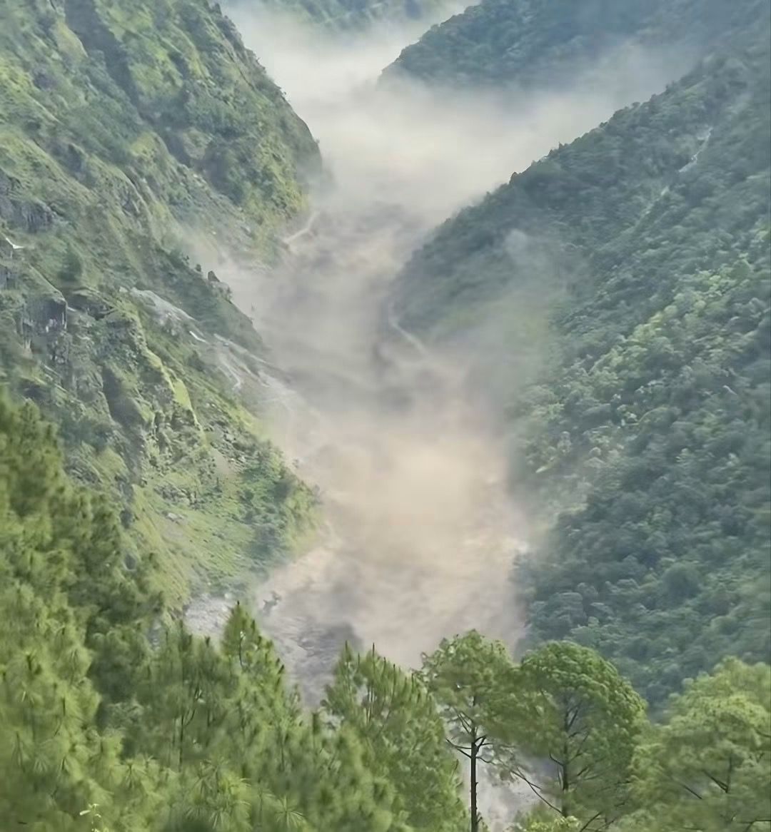
The devastating Bhotekoshi flash flood that struck northern Nepal on August 26, 2026, sent a powerful surge downstream through the Trishuli and Narayani river systems, causing widespread loss of life, destruction of infrastructure and major disruption across several districts.
What initially appeared to be a sudden and unexplained flood is now being linked to a massive upstream water surge originating on the Tibet side of the Nepal–China border. A preliminary technical assessment says a river blockage in Tibet created a temporary lake that subsequently burst, sending an enormous volume of water downstream into the Bhotekoshi River.
What Happened in the Bhotekoshi?
The disaster began in the upper Bhotekoshi basin in Rasuwa on the morning of August 26.
A magnitude 4.4 earthquake was recorded at around 8:37 am, followed shortly afterward by a major surge entering the Bhotekoshi from the Tibet side. Scientists initially considered an ice avalanche and possible glacial lake outburst as potential causes. A preliminary technical report now indicates that a lake formed after a river blockage in Tibet burst, releasing a huge volume of water downstream.
The exact chain of events is still being investigated, but authorities and scientists agree that this was not a normal monsoon flood. The sudden rise and enormous volume of water point toward a rapid upstream release rather than rainfall alone.
From Bhotekoshi to Trishuli
The flood rapidly travelled downstream from Rasuwa through the Bhotekoshi–Trishuli river corridor, affecting settlements, bridges, hydropower infrastructure and roads.
According to Nepal's flood forecasting authorities, the flood entered the Bhotekoshi around 9:05 am. Early warnings were then sent to communities along the Trishuli corridor in Rasuwa, Nuwakot, Dhading and Chitwan.
More than 679,000 warning SMS messages were reportedly sent to people in potentially affected areas.
The flood subsequently moved through areas including Betrawati, Malekhu, Muglin and Devghat, eventually reaching the Narayani river system.
A rapid and destructive timeline
8:37 am: A magnitude 4.4 earthquake was recorded.
Around 9:05 am: A major flood surge entered the Bhotekoshi from the Tibet side.
9:15–9:16 am: Flood warnings were sent to communities along the Trishuli corridor.
Around 11:26 am: Water at the Furke/Malekhu gauge exceeded the danger level.
11:43 am: Floodwaters swept away a bridge and other structures around Malekhu.
1:00 pm: The flood had passed Muglin, prompting further warnings downstream.
Around 3:20 pm: The flood reached the Devghat/Narayani area.
4:00 pm: Devghat recorded a peak water level of about 6.57 metres before the level began falling.
By 6:30 pm: Water levels at Devghat had fallen substantially.
The preliminary technical assessment estimates that approximately 20 million cubic metres of additional water passed through the Devghat area during the event.
Heavy Damage Along the River Corridor
The flood caused extensive destruction in Rasuwa and downstream areas.
In Trishuli Bazaar and Devighat, local reports said dozens of houses were swept away or damaged. Bridges, hydropower facilities and other infrastructure along the river were also affected.
The disaster also damaged hydrological monitoring infrastructure. Four automatic hydrological monitoring stations were swept away, making real-time monitoring and subsequent analysis more difficult.
Several hydropower projects in the Bhotekoshi corridor were also severely affected, highlighting the vulnerability of Nepal's hydropower infrastructure to extreme flood events.
Human Toll and Search-and-Rescue Efforts
The human toll has continued to rise as rescue teams reach remote and heavily damaged areas.
As of August 27, 2026, reports indicated that at least 165 people had died across Nepal and Tibet, while hundreds remained missing. The situation remains fluid, and authorities continue to update casualty and missing-person figures as search operations progress.
Tourists, pilgrims, workers and local residents were among those affected. The flood also struck an important route used by travellers heading toward Tibet and the Kailash Mansarovar region.
Search-and-rescue operations are continuing, with Nepalese security forces, local authorities and international partners involved in the response.
Is Another Trishuli–Bhotekoshi Flood Coming?
This is one of the biggest concerns for communities living along the river.
Authorities have urged people in vulnerable settlements along the Bhotekoshi, Trishuli and downstream river corridors to remain alert and move to safer, higher ground if instructed.
However, the latest available assessments do not indicate a reliable sign of another flood of the same magnitude at this time. Heavy rainfall remains a concern, and authorities continue to monitor river levels and upstream conditions.
People living close to the river should therefore continue following official warnings rather than assuming that falling water levels mean the danger has completely passed.
What Does This Disaster Tell Us About Nepal's Mountain Rivers?
The Bhotekoshi–Trishuli disaster is a powerful reminder that flood risk in Nepal's mountains is not limited to heavy monsoon rainfall.
Nepal's high-altitude river systems can be affected by:
Glacial lake outburst floods
Ice and rock avalanches
Landslides blocking rivers
Sudden lake releases
Extreme rainfall
Earthquake-triggered slope failures
Rapid changes in glaciers and high-altitude lakes
The Himalayas are warming rapidly, increasing concern about the stability of glaciers, glacial lakes and mountain slopes. Scientists have therefore emphasized the need for stronger monitoring, early-warning systems and cross-border information sharing.
The Importance of Early Warning Systems
One positive lesson from this tragedy is the role of early warning.
Although the flood developed extremely quickly, authorities were able to send hundreds of thousands of SMS warnings to downstream communities. Those warnings helped some residents move away from vulnerable areas before the flood arrived.
This demonstrates why Nepal needs to continue investing in:
Real-time river monitoring → upstream surveillance → rapid data sharing → public alerts → community evacuation plans.
Early warning cannot prevent a flood, but it can save lives.
What Happens Next?
The immediate priority is search and rescue, medical assistance, temporary shelter and restoring essential infrastructure.
The longer-term challenge will be understanding exactly what caused the flood and how similar events can be detected earlier.
Nepal also needs stronger cooperation with China and other Himalayan countries to monitor high-altitude glaciers, lakes and river systems that cross or influence national borders.
The Bhotekoshi and Trishuli rivers are not only natural waterways. They support communities, hydropower, transportation, tourism, agriculture and local economies. Protecting the people who live along these rivers requires treating extreme flood risk as a long-term national priority.
A Warning for the Future
The 2026 Bhotekoshi–Trishuli flood will be remembered as one of Nepal's most devastating sudden flood disasters.
From the high Himalayas near the Tibet border to the Trishuli corridor and the Narayani at Devghat, the event demonstrated how quickly a disaster originating in a remote mountain valley can travel hundreds of kilometres downstream.
The water has begun to recede, but the recovery will take much longer.
For Nepal, the message is clear: stronger early-warning systems, better mountain monitoring, safer infrastructure and faster emergency communication are no longer optional—they are essential for protecting communities in a changing Himalayan climate.